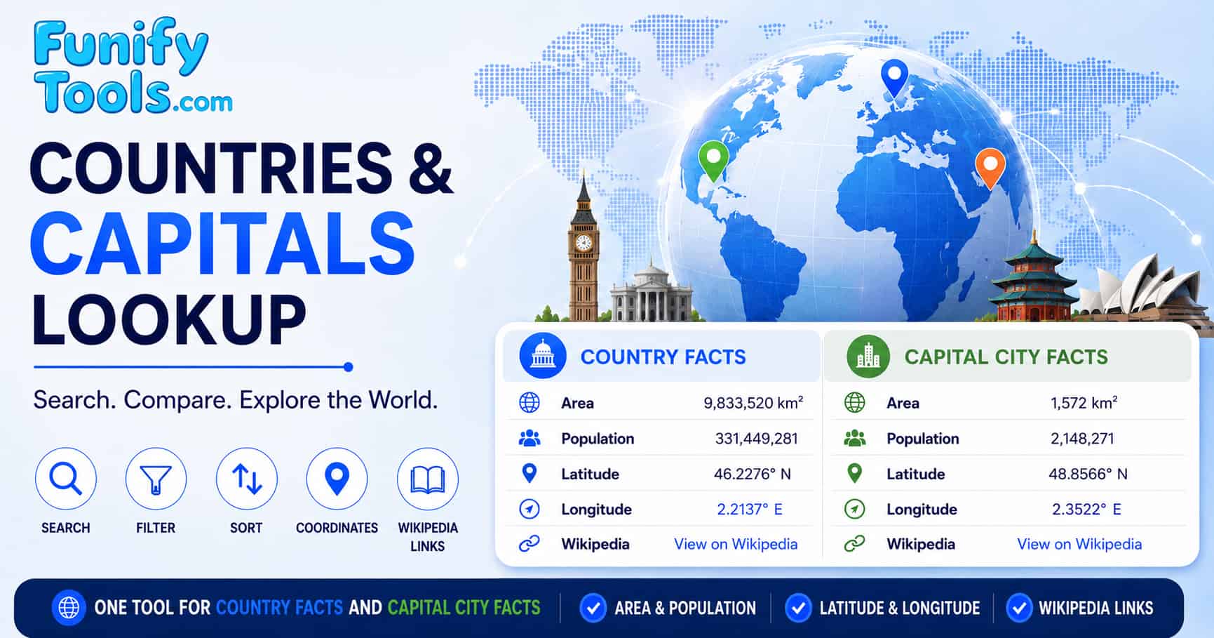
Country facts mode
Use this mode when your question is about a country as a national unit. The area column represents country area in square kilometers, and the population column represents the country population. The United Nations Statistics Division M49 standard is useful as a country and area code reference, but area and population values can still vary by source, update cycle, and boundary definition.
Population values should be treated as reference estimates rather than exact counts. They may differ from national census results because sources use different reference dates, estimation methods, and update schedules. For research, policy, or reporting work, compare the table values with a current national statistical source.
Country facts mode is useful for quick comparison, classroom reference, testing, and broad geographic browsing. Latitude and longitude are available as range filters and appear in the selected row details; they refer to the capital city location.
Capital city facts mode
Capital city mode switches the area and population columns to capital-level reference values. These values are useful for quick comparison, but city boundaries are not defined in the same way everywhere. Depending on the country and source, a value may represent a city proper, municipality, capital district, metropolitan area, or another local administrative unit.
This means capital values should not be treated as perfectly standardized density or urban planning data. For example, a compact city proper and a large metropolitan region can describe very different real-world areas even when both are associated with the same capital. Use this mode for lookup and broad comparison, then verify important cases with official city, national statistics, or specialist geographic sources.
When using capital city facts mode, pay special attention to boundary definitions, population reference years, and whether a source describes the capital city itself or a wider urban region.
How data is sourced and verified
The embedded dataset combines reference values from commonly available geographic and demographic sources. Population and area figures may use different reference years and administrative boundaries, especially for capital cities. Verify important figures with an official national or municipal source.
- Country values: Use them as broad national reference values and verify important cases with official national statistics or recognized geographic references.
- Capital values: Treat them as capital-level reference values. Some entries may follow city proper boundaries, while others may reflect wider capital districts or metropolitan references.
- Coordinates: Coordinates are decimal latitude and longitude values for the capital location and are suitable for map lookup, not surveying or legal boundary work.
- Updates: Review the dataset periodically because population estimates, administrative boundaries, and capital designations can change.
If an entry appears outdated or inconsistent, compare it with a current official source before using it for research, reporting, or other important work.
Country vs capital comparison table
The following table illustrates how national-level data compares with capital city data for selected major countries. Note the dramatic difference in scale between country area and capital city area. This comparison highlights an important geographic principle: the capital city, no matter how large or influential, represents only a tiny fraction of the country's total land area. Even in cases like the United Kingdom, where London's administrative area is relatively large at 1,572 km², it accounts for only 0.645% of the national territory.
The "Capital share of country" column is calculated by dividing the listed capital area by the listed country area. It is an illustrative size comparison only. Administrative boundary definitions differ substantially, so the percentage should not be used to infer a country's federal structure, level of centralization, or distribution of political power.
| Country | Capital | Country area (km²) | Capital area (km²) | Capital share of country |
|---|---|---|---|---|
| Russia | Moscow | 17,125,191 | 2,561 | 0.015% |
| Canada | Ottawa | 9,984,670 | 2,777 | 0.028% |
| China | Beijing | 9,596,961 | 16,411 | 0.171% |
| United States | Washington, D.C. | 9,833,517 | 177 | 0.002% |
| Brazil | Brasília | 8,515,767 | 5,802 | 0.068% |
| India | New Delhi | 3,287,263 | 1,484 | 0.045% |
| Japan | Tokyo | 377,975 | 2,194 | 0.580% |
| Germany | Berlin | 357,582 | 892 | 0.249% |
| United Kingdom | London | 243,610 | 1,572 | 0.645% |
| South Korea | Seoul | 100,210 | 605 | 0.604% |
The table shows how strongly administrative definitions affect capital-area comparisons. Washington, D.C. uses a relatively compact district boundary, while Beijing's municipality includes urban, rural, and mountainous areas. Confirm comparable boundary types before drawing conclusions from these figures.
Area classification table
Countries can be classified by total land area into distinct size categories. This classification follows the standard geographic convention used by the CIA World Factbook for land area ranking. The classification system is based on natural logarithmic breaks in the distribution of country areas, which produces meaningful categories that reflect real geographic differences rather than arbitrary thresholds. Understanding these categories helps contextualize the relative size of any given country and provides a framework for comparative geographic analysis.
The distribution of countries across these categories is highly uneven. While only 18 countries (approximately 9% of all nations) fall into the "Very large" category, these countries collectively account for over 50% of the world's total land area. At the other extreme, 22 countries in the "Very small" category represent less than 0.1% of global land area. This skewed distribution reflects the historical and geological processes that have shaped national boundaries, including colonialism, geopolitical negotiations, and natural geographic features such as mountain ranges, rivers, and coastlines.
| Category | Area range (km²) | Example countries | Number of countries |
|---|---|---|---|
| Very large | Over 1,000,000 | Russia, Canada, China, USA, Brazil | 18 |
| Large | 100,001-1,000,000 | France, Japan, Germany, Norway, UK | 53 |
| Medium | 10,001-100,000 | South Korea, Iceland, Hungary, Portugal | 58 |
| Small | 1,001-10,000 | Brunei, Cyprus, Luxembourg, Jamaica | 27 |
| Very small | Under 1,000 | Singapore, Bahrain, Maldives, Monaco | 22 |
It is worth noting that the number of countries in each category is not fixed and may change over time due to geopolitical developments. For example, the dissolution of the Soviet Union in 1991 created 15 new countries, several of which fell into different area categories. Similarly, the independence of South Sudan in 2011 added a new country to the "Medium" category. The classification system used here is based on the current set of sovereign states recognized by the United Nations, which includes 193 member states and 2 observer states (the Holy See and the State of Palestine). Some territories and dependencies are also included in this tool's dataset for reference purposes.
Population density and urban concentration
Comparing country population with capital-level population can suggest how strongly people and institutions concentrate around a capital. However, capital population values are not always defined the same way. Some sources use city proper values, while others use wider urban or metropolitan references. Treat the table below as an illustrative comparison, not as a standardized demographic ranking.
The concept of urban primacy was first formalized by geographer Mark Jefferson in 1939, who observed that in many countries, the largest city is significantly larger than the second-largest city. This phenomenon, known as the "law of the primate city," is particularly common in developing countries where economic opportunities are concentrated in the capital. In contrast, countries with more balanced urban systems, such as Germany and India, have multiple large cities that compete economically with the capital, resulting in lower primacy ratios.
| Country | Capital | Country population | Capital reference population | Reference share |
|---|---|---|---|---|
| Japan | Tokyo | 123,294,513 | 37,400,068 | 30.3% |
| South Korea | Seoul | 51,709,098 | 9,701,584 | 18.8% |
| United Kingdom | London | 67,791,400 | 8,982,000 | 13.2% |
| France | Paris | 64,756,584 | 2,148,327 | 3.3% |
| Russia | Moscow | 146,150,789 | 12,655,050 | 8.7% |
| China | Beijing | 1,411,750,000 | 21,893,095 | 1.6% |
| India | New Delhi | 1,428,627,663 | 29,399,141 | 2.1% |
| United States | Washington, D.C. | 341,814,840 | 689,545 | 0.2% |
| Thailand | Bangkok | 71,697,030 | 10,539,000 | 14.7% |
| Mexico | Mexico City | 130,861,007 | 9,209,944 | 7.0% |
The table reveals several noteworthy patterns, but the shares should be read with care because the capital reference population may not always use the same boundary type. Japan's value reflects the very large Tokyo urban region used in this reference set, while Washington, D.C. reflects a much smaller capital boundary. China and India, despite having the world's largest national populations, show lower reference shares because their populations are distributed across many large cities and regions.
For accurate demographic comparison, always confirm whether each value represents a city proper, municipality, capital district, urban agglomeration, or metropolitan area. Mixing these definitions can dramatically change the apparent level of urban concentration.
Coordinate system and geographic reference
The coordinates are presented as decimal latitude and longitude values for general map lookup. The National Geospatial-Intelligence Agency WGS 84 documentation provides background on a commonly used global reference system, but this tool does not publish source metadata or accuracy estimates for each coordinate.
Latitude filters accept values from -90° to 90°, and longitude filters accept values from -180° to 180°. The number of decimal places in a value does not by itself establish real-world positional accuracy. Use these coordinates to locate a capital generally, not for navigation, surveying, or legal boundary work.
For both datasets, the coordinates refer to the capital city location. The same coordinate pair is retained when switching modes. Verify important locations with an official national mapping agency or municipal source.
Users who wish to verify or explore capital city locations further can use the coordinates in conjunction with online mapping tools. For example, entering the coordinates "35.6762, 139.6503" into Google Maps will display the location of Tokyo's government district, while "38.9072, -77.0369" will pinpoint Washington, D.C.'s National Mall area. The coordinate system also enables advanced geographic analysis, such as calculating the great-circle distance between capitals, identifying capitals that share similar latitudinal bands, or mapping the global distribution of capital cities relative to population centers and economic regions.
Advanced search techniques and filtering
The countries and capitals lookup tool supports multiple search and filtering methods to help users quickly find the information they need. Understanding these techniques can significantly improve the efficiency of your data retrieval and enable more sophisticated geographic analysis.
Keyword search: The primary search method allows you to type any text into the search box, and the tool filters the dataset to show rows that contain matching text in the country, capital, or Wikipedia slug fields. This means you can search by country name, capital name, or partial matches. For example, typing "stan" will return countries ending with "-stan" such as Afghanistan, Kazakhstan, Pakistan, and Uzbekistan.
Dataset switching: Switch between Country facts and Capital city facts without changing your search workflow. The dataset does not include region or continent fields, so searches such as "Europe" or "Asia" will not return regional groups.
Column sorting: Sort the visible table by country, capital, population, or area. Latitude and longitude are available as range filters and appear in the selected row details.
For best results when searching, consider the following tips: use specific search terms rather than general ones to narrow down results; combine multiple search terms if the tool supports advanced filtering; and use the sorting feature to identify patterns and trends that may not be immediately apparent from the default alphabetical listing. Regular users of the tool will find that mastering these search techniques enables them to extract maximum value from the dataset with minimal effort.
Geographic accuracy and data limitations
This embedded reference dataset does not include record-level source dates, boundary definitions, or accuracy metadata. Review the following limitations before comparing values or using them outside casual lookup and testing.
Boundary definitions: A country's reported area can vary depending on whether territorial waters, disputed territories, and overseas regions are included. The embedded records do not provide a source and boundary definition for every value, so verify important comparisons with a source that documents its methodology.
Population estimate variability: Population figures may differ because sources use different reference dates, estimation methods, and boundaries. The embedded records do not include a source year for every value. Cross-reference figures with official national statistics when the date or methodology matters.
Capital city data challenges: Capital city data presents unique challenges because administrative boundaries vary significantly between countries. Some capital cities, like Berlin and Vienna, are city-states whose administrative boundaries encompass the entire urban area. Others, like London and Tokyo, have administrative boundaries that cover only a portion of the continuous urban development. This means that comparing capital city areas and populations directly without understanding the administrative context can lead to misleading conclusions. Users are encouraged to consult additional sources for capital city data when conducting detailed comparative analysis.
Geopolitical changes: The political geography of the world is constantly evolving. New countries may be formed through independence movements or secession, existing countries may merge or dissolve, and capital cities may be relocated for political or practical reasons. For example, Burma (Myanmar) officially changed its capital from Yangon (Rangoon) to Naypyidaw in 2005, and Kazakhstan moved its capital from Almaty to Nur-Sultan (formerly Astana) in 1997. This tool is updated periodically to reflect such changes, but users should verify the current status of any country or capital that may be subject to recent geopolitical developments.
Coordinate limitations: Capital coordinates can refer to different points, such as an administrative center or a representative city location. Decimal formatting does not guarantee positional accuracy. Consult an official mapping source for navigation, surveying, or other location-sensitive work.
How capital cities are designated
The designation of a city as a national capital is a complex process that varies significantly across countries and historical periods. Understanding how capital cities are selected and why certain cities become capitals provides valuable context for interpreting the data in this lookup tool and for understanding the broader patterns of political geography.
Historical evolution: Many capital cities have evolved organically over centuries, growing from small settlements into major political and economic centers. London, Paris, and Tokyo are examples of capitals that have served as the seat of government for hundreds or even thousands of years. These cities typically became capitals because they were already the largest and most important cities in their respective countries, serving as centers of trade, culture, and political power. The concentration of political, economic, and cultural institutions in these cities has reinforced their dominance over time, creating a self-perpetuating cycle of growth and influence.
Deliberate design: Some capital cities were deliberately planned and constructed to serve as national capitals. Washington, D.C., Brasília, Canberra, and Islamabad are prominent examples of purpose-built capitals that were designed to balance regional interests, promote national unity, or symbolize a new political order. Washington, D.C. was established as a compromise between Northern and Southern states following the American Revolution, while Brasília was built in the interior of Brazil to encourage development away from the coastal population centers. These planned capitals often feature distinctive architectural and urban planning elements that reflect the political and cultural values of their founding periods.
Compromise and balance: In some countries, the capital city is chosen as a compromise between competing regions or ethnic groups. For example, South Africa has three capital cities: Pretoria (administrative), Cape Town (legislative), and Bloemfontein (judicial), reflecting the country's complex federal structure and historical divisions. Similarly, the Netherlands has Amsterdam as its constitutional capital and The Hague as the seat of government, a distinction that dates back to the Dutch Republic period. Bolivia's constitutional capital is Sucre, but the seat of government is located in La Paz, reflecting historical tensions between different regions of the country.
Relocation and change: Capital cities are not immutable and can be relocated for various reasons. In recent decades, several countries have moved their capitals to address regional imbalances, reduce congestion in overcrowded megacities, or symbolize a new political direction. Examples include Nigeria's move from Lagos to Abuja (1991), Malaysia's development of Putrajaya as the administrative capital (1999), Myanmar's move from Yangon to Naypyidaw (2005), and Egypt's ongoing development of a new administrative capital east of Cairo. These relocations are typically massive infrastructure projects that take decades to complete and involve the construction of entire government districts, residential areas, and transportation networks.
Understanding the diverse ways in which capital cities are designated helps users appreciate the rich historical and political context behind the data in this tool. It also explains why some capital cities are relatively small and obscure (such as Bern, Switzerland or Wellington, New Zealand) while others are among the world's largest and most influential cities. The choice of capital reflects each country's unique history, political system, and national identity, making the study of capital cities a fascinating window into the diversity of human political organization.
Practical applications and use cases
The countries and capitals lookup tool has a wide range of practical applications across multiple fields and disciplines. Understanding these use cases can help users maximize the value of the tool and apply its data to real-world problems and research questions.
Education and learning: Students and educators can use this tool as a supplementary resource for geography lessons, social studies classes, and international relations courses. The search, range filters, and sortable columns can support study materials such as countries ranked by population or area, capitals within a selected latitude range, or comparisons between national and capital-level figures. Teachers can use the tool to generate quizzes, assign research projects, or facilitate classroom discussions about geographic patterns. The coordinate data also provides a practical introduction to geographic information systems (GIS) and spatial thinking.
Travel planning: Travelers and travel professionals can use the tool to quickly find information about destination countries and their capital cities. The coordinate data can be used to plot travel routes, calculate distances between capitals, or identify countries in specific latitudinal bands for climate and seasonal planning. The area and population data provide useful context for understanding the scale and character of different destinations, helping travelers make informed decisions about where to visit and what to expect.
Business and market research: International businesses and market researchers can use the tool to analyze market opportunities, evaluate country-level demographics, and understand the geographic distribution of economic activity. The population data provides a baseline for market size estimation, while the area data offers context for logistics and distribution planning. The capital city data is particularly relevant for businesses that operate in or target national capitals, as these cities are typically centers of government, commerce, and international trade.
Data exploration and reporting: Journalists and analysts can use the tool as a starting point for finding and comparing records. Verify figures, reference years, and boundary definitions with a cited official or specialist source before publication.
Software development and API integration: Developers can use the data from this tool as a reference dataset for building applications that require country and capital city information. The structured data format makes it easy to integrate into databases, web applications, and mobile apps. The coordinate data can be used with mapping APIs such as Google Maps, Mapbox, or Leaflet to create interactive map visualizations that display capital city locations, calculate distances, or generate geographic overlays.
Students, teachers, travelers, journalists, and developers can use the lookup for quick exploration and testing. Treat it as a convenient starting point and verify important values before using them in research, reporting, navigation, or policy work.
Largest countries by population and their capitals
The following table compares selected country populations with the capital reference populations stored in this dataset. The percentages are illustrative because country and capital values may use different reference years, and capital figures may describe different boundary types.
Do not use these shares alone to infer urban primacy, political centralization, or the effect of capital status. Those questions require consistently defined city boundaries, aligned reference years, and additional economic and administrative evidence.
| Rank | Country | Capital | Population | Capital population | Capital share |
|---|---|---|---|---|---|
| 1 | India | New Delhi | 1,428,627,663 | 29,399,141 | 2.1% |
| 2 | China | Beijing | 1,411,750,000 | 21,893,095 | 1.6% |
| 3 | United States | Washington, D.C. | 341,814,840 | 689,545 | 0.2% |
| 4 | Indonesia | Jakarta | 281,603,800 | 10,562,088 | 3.8% |
| 5 | Pakistan | Islamabad | 241,499,431 | 1,095,064 | 0.5% |
| 6 | Nigeria | Abuja | 229,152,217 | 1,693,400 | 0.7% |
| 7 | Brazil | Brasília | 216,422,446 | 4,803,877 | 2.2% |
| 8 | Bangladesh | Dhaka | 173,562,364 | 10,278,000 | 5.9% |
| 9 | Russia | Moscow | 146,150,789 | 12,655,050 | 8.7% |
| 10 | Mexico | Mexico City | 130,861,007 | 9,209,944 | 7.0% |
This table reveals several important patterns in global demography and political geography. First, the capital share tends to be higher in countries with a single dominant city (such as Russia, Mexico, and Japan) compared to countries with multiple major urban centers (such as the United States, China, and India). Second, purpose-built capitals like Washington, D.C., Islamabad, and Abuja have significantly lower population shares than historically evolved capitals like Moscow, Mexico City, and Dhaka. Third, the relationship between national population rank and capital city population rank is not linear: India is the most populous country but New Delhi is only the second-largest capital city in the dataset by metropolitan population, while Jakarta (Indonesia) and Dhaka (Bangladesh) have capital population shares that are disproportionately high relative to their national population ranks. These patterns reflect the complex interplay of historical development, government policy, and economic geography that shapes the distribution of population within each country.
Capital cities with extreme geographic coordinates
The following table lists capital cities that occupy extreme geographic positions in terms of latitude, longitude, and elevation. These capitals demonstrate the remarkable diversity of locations where national governments are situated, from the frozen Arctic to the tropical equator, and from sea-level coastal plains to high-altitude mountain valleys. Understanding the geographic extremes of capital cities provides insight into the relationship between physical geography and political organization, as well as the environmental challenges faced by different countries.
The geographic position of a capital city has profound implications for its climate, accessibility, and economic development. Capitals located at high latitudes, such as Reykjavik and Helsinki, experience extreme seasonal variations in daylight hours, with very short winter days and very long summer days. These conditions affect energy consumption, transportation infrastructure, and the daily rhythms of life. Conversely, capitals located near the equator, such as Quito and Nairobi, experience minimal seasonal variation in daylight and temperature but face challenges related to tropical climate, including heavy rainfall, humidity, and vector-borne diseases. High-altitude capitals like La Paz and Quito must contend with reduced atmospheric pressure, which affects everything from cooking times to athletic performance, while low-lying capitals like Copenhagen and Amsterdam face the growing threat of sea-level rise due to climate change.
| Category | Capital | Country | Coordinate | Value | Notable characteristic |
|---|---|---|---|---|---|
| Northernmost capital | Reykjavik | Iceland | Latitude | 64.1466° N | Northernmost capital of a sovereign state; experiences midnight sun in summer and polar night in winter |
| Southernmost capital | Wellington | New Zealand | Latitude | 41.2865° S | Southernmost capital of a sovereign state; located on the Cook Strait at the southern tip of North Island |
| Highest capital | La Paz | Bolivia | Elevation | 3,640 m (11,942 ft) | Highest administrative capital in the world; seat of government while Sucre is constitutional capital |
| Lowest capital | Baku | Azerbaijan | Elevation | −28 m (−92 ft) | Lowest capital city in the world; located 28 meters below sea level on the Caspian Sea coast |
| Easternmost capital | Suva | Fiji | Longitude | 178.4419° E | Easternmost capital of a sovereign state; located on the island of Viti Levu in the South Pacific |
| Westernmost capital | Apia | Samoa | Longitude | 171.7513° W | Westernmost capital of a sovereign state; located on the northern coast of Upolu Island |
| Equator-adjacent capital | Quito | Ecuador | Latitude | 0.1807° S | Closest capital to the equator; located in the Guayllabamba river basin in the Andes at 2,850 m elevation |
| Most inland capital | Kampala | Uganda | Distance from coast | ~800 km (497 mi) | One of the most landlocked capitals; located on the shores of Lake Victoria in East Africa |
The diversity of capital city locations reflects the wide range of geographic, historical, and political factors that influence where national governments are established. Some capitals, like Reykjavik and Wellington, are located at the geographic extremes of their respective continents because their countries were settled from the sea and the capitals developed at the primary ports of entry. Others, like La Paz and Quito, are located in high-altitude regions because the indigenous populations and colonial settlements were concentrated in the temperate highlands rather than the tropical lowlands. Still others, like Baku and Kampala, occupy unusual positions due to specific historical circumstances, such as the location of natural resources (oil in the case of Baku) or the desire to establish a centrally located capital that serves as a symbol of national unity. Understanding these geographic extremes helps users appreciate the remarkable variety of environments in which human political organization operates and the adaptive strategies that different societies have developed to govern their territories.
Countries with multiple capital cities
While most countries have a single capital city where all branches of government are located, several countries around the world maintain multiple capital cities for different governmental functions. This arrangement typically arises from historical compromises, federal structures, or the desire to balance regional interests. Understanding these multi-capital systems provides insight into the political geography of these countries and the complex relationships between territory, governance, and national identity. The following table lists countries that have more than one officially designated capital city, along with the specific governmental functions housed in each location.
Multi-capital systems can be classified into several categories based on their historical origins and functional organization. Some systems, like South Africa's, were deliberately designed to balance regional interests following the end of apartheid. Others, like the Netherlands', are the result of historical evolution where different cities have traditionally hosted different branches of government. Still others, like Malaysia's, reflect a deliberate policy of decentralization, where a new administrative capital was built to relieve congestion in the original capital while maintaining the original capital's symbolic and constitutional status. The coexistence of multiple capitals within a single country creates unique administrative challenges, including the need for efficient transportation and communication links between capital cities, coordination of government functions across multiple locations, and the maintenance of duplicate facilities and infrastructure.
Multi-capital systems present both advantages and challenges for governance. On the positive side, distributing government functions across multiple cities can promote regional economic development, reduce congestion and housing costs in any single city, and provide symbolic recognition of regional diversity within a country. For example, South Africa's three-capital system explicitly recognizes the historical and cultural significance of different regions, while Malaysia's Putrajaya was designed to develop a previously underdeveloped region and create a modern, purpose-built administrative center. On the negative side, multi-capital systems require additional infrastructure and transportation costs, can create coordination challenges between government branches, and may lead to confusion among citizens and international visitors about which city serves as the official capital. The existence of multiple capitals also has practical implications for diplomacy, as foreign embassies must decide whether to locate near the administrative capital, the legislative capital, or both. Despite these challenges, multi-capital systems continue to function effectively in several countries around the world, demonstrating the flexibility of political geography in accommodating diverse historical circumstances and governance needs.